18 Best Views of Lake Tahoe [Scenic Viewpoints By Car, Hike & More]
KEY TAKEAWAYS
- The best views of Lake Tahoe are from Emerald Bay State Park Lookout, Sand Harbor State Park, and D.L. Bliss State Park.
- Some of these spots have free limited parking, while others have paid parking lots.
- Our favorite viewpoints are from Maggie’s Peaks and the Rubicon Trail.
We visit Lake Tahoe several times a year to enjoy the hiking trails, beaches, snow, and fresh mountain air, as it’s an easy drive for us.
We’re always searching for the best viewpoints in Lake Tahoe, whether it’s a quick stop along the lake or a hike to the top of the mountain.
With 72 miles of shoreline nestled within beautiful mountain ridges and peaks, Lake Tahoe has no shortage of viewpoints.
Check out our list of the best Lake Tahoe viewpoints, complete with everything you need to know, from parking to the best time to visit.
🚐 If you’re strapped for time, this half-day tour with a small group visits the best viewpoints in South and West Shore, while this full-day tour circles the scenic points around the entire lake.


Best Views of Lake Tahoe
For a destination as picturesque and scenic as Lake Tahoe, it would be a waste to visit the area without looking for the best spot to enjoy the scenery.
Some viewpoints are easily accessed by driving and finding a parking spot, while some may require a bit more work.
Ultimately the payoffs are always worth the effort.
All locations listed below are accessible during the summer, but some that include hiking trails may be inaccessible during winter due to road closures and unmaintained trails.
Best Views of Lake Tahoe by Car
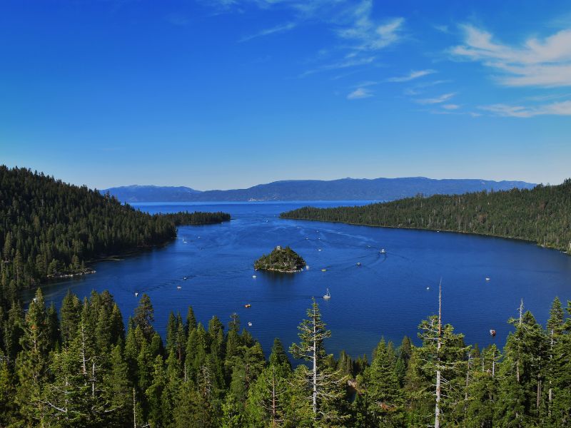
Emerald Bay State Park Lookout
- Parking: limited parking
- Accessibility: drive-up, short hike-in
- Fees: $3/hr, $10/day
- Google Map
Less than a mile from Inspiration Point, the Emerald Bay Lookout gives a more outright and unobstructed view of the bay and Fannette Island.
This viewpoint also offers good access to the trail that leads to the water and Vikingsholm Castle.
The hike down descends 400 feet from the parking lot, which should be considered if you plan on going down to the water for a closer look.
Parking, which is $3/hour, can be difficult, especially during the peak season.
If you don’t mind hiking in, you can park for free further up the road on the opposite side or by the Eagle Falls trailhead lot.
DL Bliss State Park


- Parking: pay-to-park lot
- Accessibility: drive-in, hike-in, bike-in
- Fees: $10 state park fee
- Google Map
The DL Bliss State Park is located on the southwest edge of the lake next to Emerald Bay State Park and is home to various hiking trails that offer some of the best Lake Tahoe views.
Trails here are long and can take hours to complete, but the payoff is that the views of the shoreline offer stunning glimpses of the crystal-clear waters.
The beach is also just a short walk from the parking lot, which makes it a great place to spread a family picnic and relax while enjoying the majestic views of the lake and its surrounding nature.
Local Tip: Parking fills up early, especially on weekends. Once full, there is free parking on the road, but it’s an additional 1.5 miles to the start of the trail.
Inspiration Point

- Parking: Limited paid parking, can also park across the street at Bayview Day Use Area
- Accessibility: drive-up, car pull-off to take pics side of the street, walk-in
- Fees: $5 Day Use fee (30 minutes)
- Google Map
With a vantage point located 600 feet above Lake Tahoe, visitors of Inspiration Point will find themselves with the perfect overlook of the entire Emerald Bay and its stunning features.
Accessible paved walkways with interpretative signs and a viewing deck within a short walk from the parking lot make this an ideal stop for families with kids and large groups.
Car pull-offs near Inspiration Point also give unobstructed views for the perfect sunrise shot of Lake Tahoe.
However, Highway 89 may be closed during heavy winters, so check with authorities ahead if you plan on going here.
Local Tip: This Lake Tahoe vista point gets very busy and has limited parking, so be prepared to wait until a spot opens up or try to find parking across the road. However, if you visit during the shoulder season such as in October, you won’t have to deal with the crowds.
Sugar Pine Point State Park
- Parking: pay-to-park lot
- Accessibility: drive-in
- Fees: $10 state park fee
- Google Map
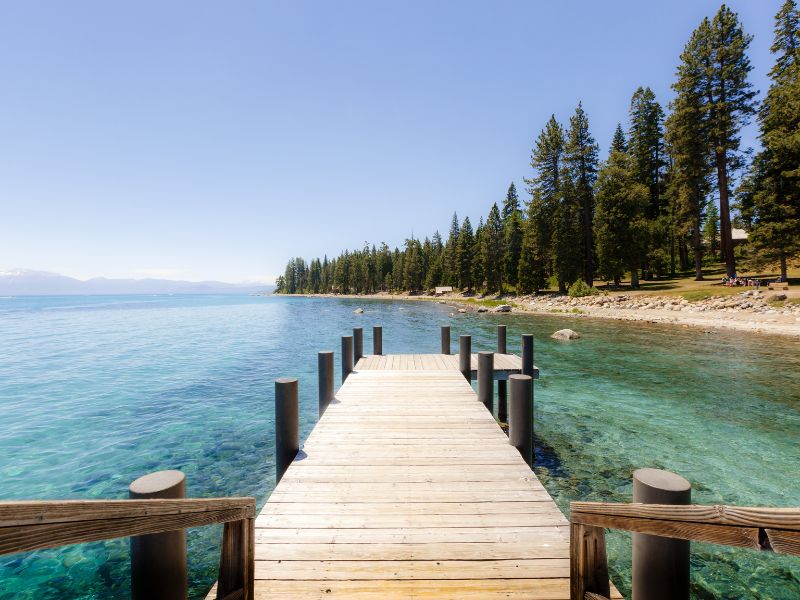
When driving around Lake Tahoe, particularly on the west shore, stop by Sugar Pine Point and take a scenic shot of the lake with your family or friends from its pier.
Its huge parking lot makes for easy parking, which can’t be said for the other picture-worthy places around the Lake Tahoe shore.
Sugar Pine Point provides easy access to one of the best beaches in Tahoe, as well as hiking and biking trails along the shore.
Local Tip: Make sure to set the google map location to this spot to get access to the pier and the lake.
Lake Tahoe Scenic Overlook
- Parking: street parking
- Accessibility: drive-in
- Fees: Free
- Google Map
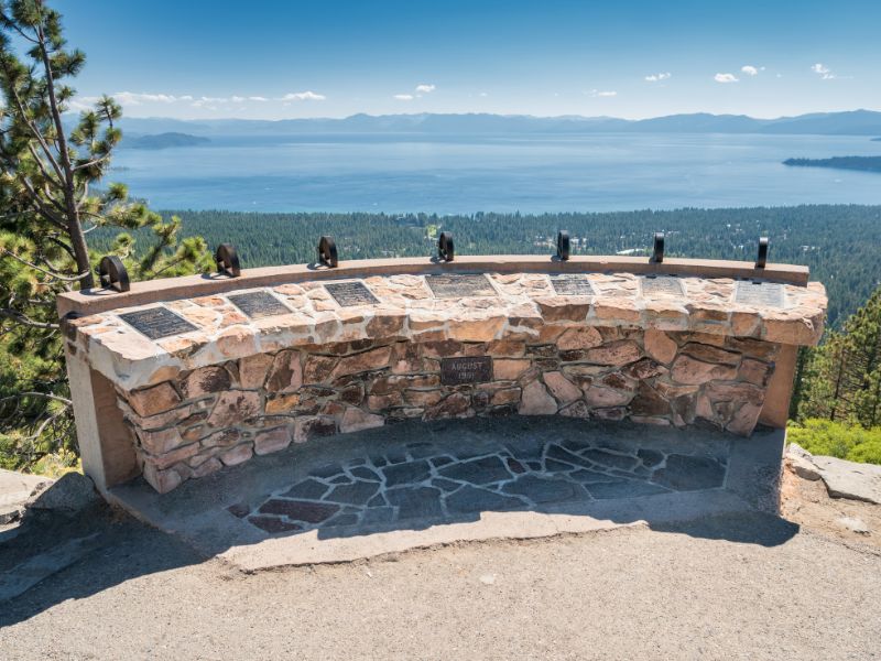
If you happen to be visiting near King’s Beach, take a short detour on Mount Rose Highway in Incline Village and drive for about 15 minutes inland to the Lake Tahoe Scenic Overlook.
This Lake Tahoe viewpoint may be far from the usual landmarks highway turnoff, but the lake’s panoramic views make this stop worth it.
Parking is easy and free, and you’ll be rewarded with some of the best views of Lake Tahoe.
LOCAL TIP: Looking for the best California Christmas vacation? Lake Tahoe is one of the best places to spend the holidays!
Memorial Point Scenic Overlook

- Parking: free parking area, parking along Hwy 28 is prohibited
- Accessibility: 0.5-mile trail
- Fees: Free
- Google Map
Memorial Point Scenic Overlook has vast open views of Lake Tahoe.
This viewpoint is located between Incline Village and Sand Harbor, just off Highway 28.
If you’re hiking or biking the Tahoe East Shore Trail, you can access this spot as it sits on the trail.
Parking here is free, and it’s only a short dirt path to the shore, where views of the lake open right in front of you.
Granite boulders line up along the shore, which you can use as platforms for taking pictures or sit quietly as you take in the views.
Local Tip: The free parking lot has a 20-minute limit.
Cave Rock

- Parking: very limited a pay-to-park lot
- Accessibility: 0.8 mile hike
- Fees: $15/vehicle
- Google Map | Trail
Cave Rock is known to the Washoe Indians as “Standing Gray Rock,” a huge rock formation that towers along the shore near Zephyr Cove.
A hole was blasted in it where now US Highway 50 passes.
This trail is considered relatively easy and kid-friendly and would take less than 30 minutes to complete, but a bit of rock climbing and scrambling may be required towards the end to get to the top of the rock.
Alternatively, if you don’t feel like hiking, you can just park and admire the views from there.
Schedule your hike in the afternoon since this is one of the best places to watch the sunset in Lake Tahoe.
If you’re coming from South Lake Tahoe, Cave Rock is just before you reach the tunnel, and you can easily miss the turnout if you’re not paying attention.
Local Tip: If the parking lot is full, head over to Logan Shoals Vista Point, which is a mile up the road.
💎 READ MORE: Wondering where to stay in Lake Tahoe? Check out this post for the Best Lake Tahoe Hotels with a View.
Lake Tahoe Viewpoints
Sand Harbor State Park

- Parking: pay-to-park lot, parking along Hwy 28 is prohibited
- Accessibility: drive-in, bike-in
- Fees: $15 (out-of-state plate cars), $10 (Nevada plates), $2/bike
- Google Map
Sand Harbor is located south of Incline Village and is a popular destination because of its crystal clear waters, year-round scenic views of the lake and the surrounding mountains, and the many activities offered here throughout the summer.
Don’t miss walking the Sand Harbor Nature Trail, which is a 0.5-mile-long boardwalk with interpretative signs.
Take your pick of the best points to take pictures of beautiful Lake Tahoe, as there will be many.
The park is well maintained even during snowy weather and has one of the best views of Lake Tahoe in winter.
Local Tip: Parking here can get crazy during summer, so arrive early in the morning (7 am!), or you might get turned away when it’s full.
Tahoe East Shore Trail

- Parking: paid parking, off-street parking nearby
- Accessibility: 6-mile hike roundtrip
- Fees: $1/hour
- Google Map | Trail
The Tahoe East Shore Trail is a newly renovated 3-miles end-to-end, fully paved trail that connects Incline Village on the north shore to Sand Harbor Beach.
This hike is mostly flat, accessible, and very kid and dog-friendly.
One of the best ways to enjoy this trail is by bike, and this guided half day e-bike tour is a fun way to see the incredible views of the lake.
This trail is an excellent option if you’re looking for a bit of adventure along the lakeshore with your family or a large group of friends.
Paid parking fills up quickly, so be sure to come here early or visit during the winter when it is mostly empty.
The backdrop of crystal blue waters and snow-capped mountains makes the scenery very picturesque and easily one of the best views of Lake Tahoe.
Local Tip: There is free 20-minute parking at the overlook area, but it’s better to park at the paid lot up north that has plenty of spots.
Stateline Fire Lookout

- Parking: Very limited roadside parking (always park on the right side of the road)
- Accessibility: about 2-mile hike-in
- Fees: Free
- Google Map | Trail
The Stateline Fire Lookout is one of the underrated Lake Tahoe viewpoints in the North Shore.
You can reach it via a paved trail located in a residential area on Crystal Bay on the north side of Lake Tahoe.
The trail, from which its name was derived, starts in Nevada and ends on the California side of the lake.
You will find what’s left of the historic Stateline Fire Lookout tower on the California side of the trail.
In its place are stone viewpoints with interpretative signs overlooking Lake Tahoe.
Local Tip: Take the short trail that loops around the lookout to see different options before settling on the observation point for the ultimate panoramic view of the lake.
Monkey Rock

- Parking: pay-to-park near Tunnel Creek Café, free off-street parking (farther away)
- Accessibility: 2.6-mile hike
- Fees: $6/hour parking
- Google Map | Trail
If you’re looking for a short hike with an awesome reward at the end, take the Tunnel Creek Trail near Incline Village for one of the best views in North Lake Tahoe.
Start your hike from the left side of Tunnel Creek Cafe and follow the paved road behind.
When the trail splits, hang left and follow the green gate with the yellow tape until you reach the top of the hill, where you will find an assortment of large rocks.
Be warned that the hill is a real lung and leg burner.
Keep an eye out for the famous Lake Tahoe gorilla head rock that overlooks the east shore.
Local Tip: You will have to pay $6 for parking at the paid lots adjacent to Tunnel Creek Cafe unless you’re eating at the cafe.
Eagle Rock

- Parking: limited parking at the trailhead
- Accessibility: 0.75-mile hike
- Fees: Free
- Google Map | Trail
Located about 5 miles south of Tahoe City, on Hwy 89, is an eroded dormant volcano that is considered one of Lake Tahoe’s best scenic spots.
The trail to the top is short and only takes about 20 minutes but it can be steep and rocky in some places.
Parking is very limited and can be easy to miss, so make sure to keep your eyes peeled as you get closer.
The summit offers panoramic views of the lake, the nearby valley, and the surrounding mountains.
Local Tip: Even though it’s a short hike, make sure to wear proper shoes since some spots are steep and slippery.
Rubicon Trail

- Parking: pay-to-park lot at D.L. Bliss State Park
- Accessibility:
- Fees: $10/day use fee per state park
- Google Map | Trail
The Rubicon Trail is a narrow trail that varies in terrain with ups and downs and turns following the coast connecting DL Bliss to Emerald Bay.
One of the best views in Tahoe can be seen from this 16-mile trail, which can be easily split into shorter sections.
You can start this trail from different points, such as at D.L. Bliss State Park, Vikingsholm, or at Eagle Point Campground, although our favorite is from DL Bliss.
If you visit this trail in the Spring, you may find some snow on the ground, but most of the trail is accessible.
If you make your way to the Eagle Point Campground, which is one of the best camping spots in Lake Tahoe, a bench at the edge of the basin overlooking Lake Tahoe awaits you.
Local Tip: Parking can be difficult, so try to arrive early or go during the week.
Maggie’s Peaks

- Parking: Bayview Day Use parking area, along Hwy 89
- Accessibility: 4.5-mile hike
- Fees: $10/day use fee
- Google Map | Trail
Up for a bit of a challenge with rewarding panoramic views of Emerald Bay, Lake Tahoe, Granite Lake, and Desolation Wilderness?
Maggie’s Peaks just might be the incline hike for you.
The trail to the peaks starts at Bayview trailhead and follows the Granite Lake Trail.
Before reaching Granite Lake, there is a great lookout point of Emerald Bay without the tourists crowding your vantage point.
If you’re hiking during the summer in Tahoe, you can dip your feet and cool off at Granite Lake.
This is a steep and challenging trail that can take about 3 hours roundtrip.
You will need to be in good shape or have an iron will to get to the top, but the views are absolutely worth it. Make sure to bring enough water in your daypack to stay hydrated.
Local Tip: There is limited parking at the Bayview trailhead, so plan accordingly.
Heavenly Gondola

The Heavenly Gondola at the Heavenly Ski Resort in South Lake Tahoe is a 2.4-mile ride up a mountain face that takes you to an observation deck offering breathtaking views of the lake’s pristine waters.
The ride to the deck takes 10 minutes and costs $69 for adults, $54 for teens/seniors, and $34 for children.
Once you get to the top, you can take the Tamarack chairlift using your gondola ticket to see more breathtaking views of Lake Tahoe.
If you visit during the winter, you will enjoy vast views of the lake with snow covering the surrounding landscape.
However, since the gondola is in a ski resort, the gondola is closed for sightseers during very busy ski days. See other ski resorts in Lake Tahoe.
Local Tip: Take the gondola before 2 pm to have better lighting of the lake.
Go on a Scenic Cruise around Lake Tahoe

For a more relaxed on-the-water experience, take a 2-hour scenic cruise around South Lake Tahoe on a luxurious 70 ft boat operated by Lake Tahoe Bleu Wave, with a glass of champagne on hand.
From this vantage point, you’ll have 360-degree panoramic views of Lake Tahoe with a backdrop of snow-capped mountains.
Along with this unique viewpoint of Lake Tahoe, you’ll get a personal narration of the fun facts about the Lake.
The boat is fully decked out with a stocked bar with a fireplace and a private lounge to ensure a comfortable ride as you sit back, relax, and sip your way through Lake Tahoe’s scenic spots.
Local Tip: Love being on the water? This clear kayak tour at Sand Harbor is one of the best ways to enjoy the views of Lake Tahoe.
Hot Air Balloon Ride

Are you looking for the best view of Lake Tahoe from a different perspective?
Why not book an early morning hot air balloon ride and experience a unique way of looking over the clear waters of Lake Tahoe.
Lake Tahoe Balloons launches and lands from the deck of Tahoe Flyer, the world’s only U.S.C.G. certified balloon launch and recovery vessel.
The ride starts just after sunrise, so make sure to layer up as it can get pretty cold over Lake Tahoe in the mornings.
The experience takes approximately 4 hours and only runs from May to October.
Best Views in South Lake Tahoe

- Inspiration Point
- Emerald Bay
- D.L. Bliss State Park
- Rubicon Trail
- Maggie’s Peaks
- Heavenly Gondola
🎁 BONUS: The Idle Hour in South Lake Tahoe is a wine bar that has one of the best sunset views in Lake Tahoe. If you like beer, check out this list of the best craft breweries in Lake Tahoe.
Best Views in North Lake Tahoe

- Sand Harbor
- Memorial Point Scenic Overlook
- Tahoe East Shore Trail
- Stateline Fire Lookout
- Cave Rock
- Monkey Rock
Lake Tahoe Viewpoints Map

Lake Tahoe Quick Facts
Best Time to Visit: Spring and Fall is the best time to go if you want to avoid the crowds. Winter is best for those into snowsports while Summer is best for great weather but it is also the most crowded.
Where to Stay: For the most conveniently located hotel in South Lake Tahoe, stay at the Black Bear Lodge for a cabin with a private hot tub and the Hyatt Regency Resort & Spa in North Lake Tahoe for a lakeside vacation.
Getting there: The closest airport to Lake Tahoe is Reno-Tahoe International which is 35 miles away. For the best flight deals, use Skyscanner to browse various airlines and prices.
Getting Around: The best way to get around Lake Tahoe is by car. Use Rentalcars.com to score the best deals on rental cars.
Best Self-Guided Tour: This audio tour from GyPSy Guide provides engaging commentary to make your trip more fun and interesting at such an incredible price!
Local Tip: Don’t forget to pack a roadside emergency kit, an insulated water bottle to stay hydrated, and a reliable powerbank to keep your gadgets charged.
FAQs
How long does it take to drive around Lake Tahoe?
The drive around Lake Tahoe takes about 3 hours without stopping, and not stopping is highly unlikely with all the great views just outside your car windows. It’s best to carve out at least 8 hours to give ample time for pull-offs and short hikes on scenic spots around the lake.
How many miles is it around Lake Tahoe?
The road along the shore of Lake Tahoe is 72 miles and is one of the most picturesque drives in America. This drive is perfect for a whole day to enjoy the scenic views and explore the lakes surrounding towns and landmarks.
Which side of Lake Tahoe is more scenic?
Lake Tahoe is scenic all over, but if you only have a limited time to explore, the lake’s southwest side with D.L. Bliss and Emerald Bay is a winner. After all, Emerald Bay is considered the second most photographed place in the United States.
Is there a scenic drive around Lake Tahoe?
Yes, there is a scenic drive around Lake Tahoe aptly named “The Lake Tahoe Scenic Drive.” It’s a beautiful paved route that covers the 72-mile loop around the lake and follows three highways: US 50, NV 28, and US 89.
Wrap-Up: Best Views of Lake Tahoe
What are you waiting for? Fill up your tank, pack up your day bag, and spend a day out exploring some of the best views of Lake Tahoe.
Whether you’re just driving around to enjoy the scenery, stopping for a bit of a hike up to get more of a vantage point, taking a cruise, or going for an early hot air balloon ride, there’s plenty of Lake Tahoe scenery to enjoy.
Related:



![11 Best Lake Tahoe Breweries in 2023 [For Beer Lovers]](https://cheftravelguide.com/wp-content/uploads/2022/06/lake-tahoe-breweries_-768x432.jpg)
![18 Best Places to See the Sunset in Lake Tahoe [Hidden Gems]](https://cheftravelguide.com/wp-content/uploads/2022/11/sunset-spot-in-lake-tahoe-768x432.jpg)
![5 Closest Airports to Lake Tahoe [Best Ways to get to Lake Tahoe]](https://cheftravelguide.com/wp-content/uploads/2022/06/closest-airport-to-lake-tahoe_-768x432.jpg)
![14 Best South Lake Tahoe Beaches [+ Hidden Gems]](https://cheftravelguide.com/wp-content/uploads/2022/06/best-south-lake-tahoe-beaches_-768x432.jpg)