
Where is Yosemite National Park [Exact Address, Entrances & Tips]
KEY TAKEAWAYS
- Yosemite National Park is located on the western slope of the Sierra Nevada Mountains in Central California.
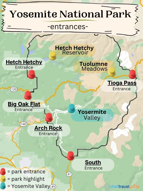
- There are 5 park entrances available depending on where you’re coming from:
- Big Oak Flat: closest to the Bay Area
- Arch Rock Entrance: less windy route from the SF Bay Area
- South Entrance: driving from Southern CA
- Tioga Pass: visiting from Mammoth Lakes or Lake Tahoe
- Hetch Hetchy: those looking to get away from the crowds
- Yosemite National Park Address (Visitor Center): 9035 Village Dr, Yosemite Valley, CA 95389, United States
Yosemite National Park is situated in the beautiful central Sierra Nevada Mountains, with its towering waterfalls and jaw-dropping granite peaks.
We know this park intimately after countless trips to the park for some epic hikes along Yosemite’s challenging trails and for some time relaxing at one of our nation’s greatest natural spectacles.
Not only will we provide you with how to find Yosemite, but we will offer up all the tips and tricks you will need for an easy and low-stress trip to this national park.
Yosemite is not only a must-visit for California residents, but it is also should be included in any itinerary for a visit to the Golden State.
Let’s start planning your trip together by first helping you figure out “where is Yosemite National Park” and what is the best way to get to the park’s top attractions.


Where is Yosemite National Park?
Yosemite National Park is located on the western slope of the Sierra Nevada Mountains in central California.
This large National Park is situated in a rural portion of the state, far from California’s major city centers, with the closest medium-sized city being Merced.
While Yosemite National Park includes 759,620 acres (1,189 sq mi; 3,074 km2) of protected land, the area of the park that sees the most traffic is the Yosemite Valley.
The Yosemite Valley is centrally located inside the park where Big Oak Flat Road, Wawona Road, and El Portal Road intersect.
For hikers, the Pacific Crest Trail also connects Mexico with Canada, and Yosemite is on the route 904 miles from Mexico and 1621 miles from the Canadian border.
The Yosemite Valley is accessible by entering any of the park’s five entrances.
Address for Yosemite National Park
9035 Village Dr, Yosemite Valley, CA 95389, United States
📌This is the address for the Yosemite Valley Visitor Center which will take you to the center of Yosemite Valley with all the must-see attractions.
Where is Yosemite National Park located on a map?
Yosemite is located on the map in Central California, about three-quarters of the width of California from the coast, and sits 150 miles east of San Francisco at the same latitude.
The easiest way to spot Yosemite on a map is to look for Lake Tahoe at the bend on the Nevada border and start to move south.
It’s important to identify the Yosemite Valley, which is just off-center in the park, where you will find the majority of the park’s top attractions.
🏙️The closest major cities to Yosemite include:
- Sacramento – 167 miles (269 km)
- San Francisco – 193 miles (311 km)
- Los Angeles – 356 miles (572 km)
🏞️Other nearby National Parks and Natural Attractions
- Sequoia and Kings Canyon National Park – 355 miles (571 km)
- Mammoth Lakes – 104 miles (167 km)
- Lake Tahoe – 186 miles (299 km)

Where is Yosemite National Park located specifically?
Yosemite is specifically located at 37.7288° N, 119.6095° W on the western slope of the Sierra Nevada Mountains in Central California.
The Yosemite Valley Visitors Center, in the heart of the park, is located 191 miles from the coast near Santa Cruz and 131 miles from the Nevada border.
🎯To identify the specific location of Yosemite National Park, use Google Maps to search for the Yosemite Valley Visitors Center, which is located in the heart of all the top attractions in the park.
What state is Yosemite National Park in?
Yosemite National Park is located in California and is centrally located in the state.
California is home to 28 national parks and 280 state parks, but Yosemite is the state’s crown jewel which draws in 3.8 million people each year.
Yosemite was first recognized as a California National Park by an act of Congress on October 1, 1890, after extensive lobbying by John Muir and Robert Underwood Johnson.
Where in California is Yosemite National Park?
Yosemite National Park is found in California halfway between the state’s northern and southern borders and is 150 miles due east of San Francisco.
In fact, the Yosemite Valley Visitor’s Center is almost exactly 443 miles from the Oregon border and 443 miles from the Mexico border at Tijuana.
The park is situated in the central Sierra Nevada Mountains, far from the state’s major cities, with Sacramento being the closest at 167 miles to the northeast.
What county is Yosemite in?
Yosemite National Park is located in four counties, including Mono, Mariposa, Tuolumne, and Madera counties.
While the majority of the park is centered in Tuolumne County, the Yosemite Valley and most of the park’s most visited natural attractions are located in Mariposa County.
This includes the Yosemite Valley, which is the central hub for tourism inside the park.
The eastern entrance to the park is located on the Tioga Pass on Highway 120 in Mono County, while the Hetch Hetchy and the Big Oak Flat entrances are located inside Tuolumne County.
The remaining two park entrances, including the Arch Rock and the South entrances, are inside Mariposa County.

What city is Yosemite National Park located in?
Yosemite National Park is not located in a city, as the park is very large, covering over 1,189 square miles (3,074 km2), which is twice as large as the city of Los Angeles.
While there are many cities and towns close to Yosemite, there are no cities inside the park as Yosemite is situated far away from the population centers in the state.
There are several very small towns with few amenities inside the park, with many having limited or no services.
The closest thing to a city in the park is Yosemite Valley, which has several options for accommodations, a few restaurants, and other services, including a few shops and stores for supplies.
Where is Yosemite Valley?
Yosemite Valley is centrally located inside Yosemite National Park and is best found by searching for the Yosemite Valley Visitors Center on Google Maps.
The Yosemite Valley is seven miles long and stretches from Vernal Falls to the east and Tunnel View vista point to the west.
To get to Yosemite Valley, you can enter the park through four of the park’s five entrances, including the Arch Rock entrance, which is only 15.3 miles to the east.
Where is Yosemite Falls?
Yosemite Falls is located inside the Yosemite Valley, which is centrally located inside the national park.
The Lower Yosemite Valley Trail and Vista Point can be found on the northern edge of the Yosemite Village, where most of the park’s services and amenities can be found.
This majestic 2425-foot tall waterfall starts to the north of the valley from Yosemite Creek and drains down the granite cliffs to the Merced River.
Where is the main entrance to Yosemite National Park?
While there is no main entrance to Yosemite National Park, the Big Oak Flat entrance is the busiest, with the majority of visitors from San Francisco and other Bay Area cities choosing this option.
It’s important to choose the right park entrance, as you will need to weigh several factors that can greatly affect your trip to Yosemite.
Each option has its benefits ranging from easy access to the Mariposa Grove near the South entrance to good options for supplies and a fill-up in Mariposa before entering the Arch Rock Park entrance.
🛣️While all the entrances offer their advantages and disadvantages, there are several factors you should consider including:
- Where are you driving from?
- Can you handle windy roads, or do you get motion sickness?
- Where you booked your accommodation
- What attractions do you want to see
- What time of year do you plan to visit
We included all the important details and tips we learned from visiting the park through all five of the park’s entrances on our many trips to Yosemite.
📢Local Tip: You can choose a different entrance from the one you plan to exit, which will give you the opportunity to see more of the park and plan a more efficient route with more attractions in a shorter period of time.
1. Big Oak Flat
- Big Oak Flat Park Entrance Address: 6107 Big Oak Flat Rd, Groveland, CA 95321, United States
- Drive Time/Distance to Yosemite Valley: 40 mins, 23.2 miles
- Highway: Highway 120 from the West / Big Oak Flat Road
🏆BEST FOR: Those traveling from the Bay Area (San Francisco, San Jose), Sacramento
For anyone planning a day trip or a weekend getaway to Yosemite from any of the Bay Area cities, including San Francisco, San Jose, and Oakland, this is the best and fastest option.
While this entrance has its advantages, it does get really busy during the summer travel season, and it’s not uncommon for the wait to get into the park to reach one hour.
We have sat in this wait a few times and have since opted to take a longer route through the Arch Rock entrance if we are visiting Yosemite from Sacramento from June through September.
For those that get motion sickness, there are some stretches of the roads and highways leading to the park that are very windy, such as the section on New Priest Grade Road.
The upside of this entrance is that there are good services and restaurants in Groveland, and one of the best accommodations, Rush Creek Lodge, is just a 5-minute drive to the gate.
It’s also important to note that if you want a picture with the famous Welcome to Yosemite sign, this entrance should be your top pick.
- 🏢Closest Big Town: Groveland
- ⛽Gas Stations: Valero (before the entrance), Crane Flat Gas Station (after)

2. Arch Rock Entrance
- Arch Rock Entrance Address: 804 El Portal Rd, Wawona, CA 95389, United States
- Drive Time/Distance to Yosemite Valley: 29 mins, 15.3 miles
- Highway: Highway 140, El Portal Road
🏆BEST FOR: A less windy drive with good accommodations along the way
If you want to avoid the crowds, the Arch Rock Entrance is the best option, and the drive is only a little longer from most destinations.
This route is less windy than getting to Big Oak Flat, and there are gorgeous views of the canyons and the Merced River, which snakes alongside Highway 140.
On the way to the park, there is an opportunity for a stop in the town of Mariposa, which has plenty of stores for supplies and some decent restaurants.
This is our favorite option for entering the park, as there are some great places to stay outside the park.
We love staying at the rustic Yosemite Bug, which has a great vibe and is perfect for last-minute bookings, and the Yosemite View Lodge, which is only an 8-minute drive to the entrance.
Pick this option, and you will feel like you found a secret entrance that allows you to sneak into the park without a long line to get through the gates.
- 🏢Closest Big Town: Mariposa
- ⛽Gas Stations: Chevron (3.2 miles before the park entrance)
3. South Entrance
- South Entrance Address: Mariposa, CA 93623, United States
- Drive Time/Distance to Yosemite Valley: 58 mins, 32.1 miles
- Highway: Highway 41 from the South / Wawona Road
🏆BEST FOR: Anyone driving from Southern California
Entering Yosemite through the southern entrance to the park comes with a few huge perks, including a first stop just inside the gates at Mariposa Grove to see the redwoods in Yosemite.
This is the best option for anyone traveling from Southern California, and this route provides the opportunity to at Tunnel View vista point before even reaching the valley floor.
We love this entrance because there is also easy access to Bridal Veil Falls, which is a great end to an amazing three-punch combo of attractions before facing the crowds in the main portion of the valley.
This option is also perfect if you need to do any shopping for supplies on the way to the park, as the town of Oakhurst is only 25 minutes before the south entrance.
Oakhurst has all the amenities and services you will need, including multiple grocery stores, lots of restaurants, a sporting goods store, and big chain hotels.
- 🏢Closest Big Town: Oakhurst
- ⛽Gas Stations: 76, Valero, Chevron (15.5 miles before the entrance), Chevron (4.6 miles after the entrance)
📢Local Tip: The road from the South entrance to Yosemite Valley is slow and windy and can take much more time (up to 1.5 hours), especially if you get stuck behind some slow cars.

4. Tioga Pass
- Tioga Pass Entrance Address: Tioga Road, Lee Vining, CA 93541
- Drive Time/Distance to Yosemite Valley: 1 hour 43 mins, 62 miles
- Highway: Highway 120 from the East / Tioga Road
🏆BEST FOR: Anyone looking to also visit Lake Tahoe or Mammoth Lakes
The Tioga Pass Entrance is a great option for anyone that not only wants a gorgeous drive but will also be looking for some extra opportunities to time outdoors.
The first thing to note about this entrance is that the Tioga Pass is only open for a short stretch of time each year, and the opening and closing dates vary depending on the snow levels.
When we visited Yosemite in early November one year, this entrance was already closed for the season.
- Typical Opening Dates: mid-May to mid-June 15
- Typical Closing Dates: Late October to mid-November
If you are planning to drive from Lake Tahoe to Yosemite, this is an incredibly scenic route for a road trip down Highway 395 with stunning views of the peaks of the Eastern Sierras.
This route also includes some natural attractions along the way, including Tenaya Lake, Tuolumne Meadows, and the Tuolumne Grove of Giant Sequoias.
For those that are also hoping to visit Mammoth Lakes from Yosemite, the Tioga Pass entrance is only a 45-minute drive to some amazing trails and Devil’s Postpile National Monument.
Choose this option for connecting multiple other stops in the Eastern Sierras or Lake Tahoe for a longer outdoor adventure.
- 🏢Closest Big Town: Lee Vining (closer but small) Bishop (farther but bigger)
- ⛽Gas Stations: Mobil, Shell, Chevron (12.2 miles before the entrance)
5. Hetch Hetchy
- Hetch Hetchy Entrance Address: Groveland, CA 95321, USA
- Drive Time/Distance to Yosemite Valley: 1:08 mins, 35.6 mins
- Highway: Highway 120 / Evergreen Road
🏆BEST FOR: A change of pace away from the crowded Yosemite Valley
If you are planning to kick off your trip to Yosemite with a relaxing hike along the shores of the Hetch Hetchy Reservoir, this is your only option.
This is the quietest entrance to the park, as less than 1 percent of visitors explore this area of the park.
Unfortunately, entering through Hetch Hetchy will not help you avoid the lines at Arch Rock, as this section of the park is not connected to Yosemite Valley.
When leaving the Hetch Hetchy Reservoir to head to the other areas of Yosemite, you will have to exit the park on Evergreen Road and get in line at the Arch Rock Entrance to re-enter the park.
This is only a good option if you want to visit the Hetch Hetchy Reservoir or if you need a break from the crowds in Yosemite Valley.
- 🏢Closest Big Town: Groveland
- ⛽Gas Stations: Valero (4.4 miles before the turn onto Evergreen Rd.)
Yosemite National Park Fun Facts

How big is Yosemite National Park?
Yosemite National Park has a total area of 1,189 square miles (3,074 km2) or 747,956 square acres.
While Yosemite is huge, it is only the 16th largest national park in the United States and is small compared to Wrangell-St. Elias National Park in Alaska, which has a total area of 20,587.19 square miles.
Yosemite is still big and has more square mileage than four of California’s largest cities combined (Los Angeles 468.7, San Diego 325.2, California City 203.5, San Jose 176.5, Bakersfield 149.7)
Visitors, on average, spend the majority of their time in the seven-mile-long Yosemite Valley, which represents less than 1% of the area making up the park.
What is Yosemite National Park known for?
Yosemite is known for its seven-mile long valley that is flanked by granite cliffs and massive waterfalls.
The top attractions in the park include Bridal Veil Falls, Half Dome, Yosemite Falls, Mist Trail, Vernal Falls, Tunnel View, and El Capitan.
Yosemite receives just under 4 million visitors each year that explore the park’s many trails to destinations within Yosemite Valley, including Mirror Lake and viewpoints like Glacier Point.
This majestic national park is also known as the center of the rock climbing world and is the traditional starting point for the John Muir Trail for through hikers.
When did Yosemite become a National Park?
Yosemite was first designated as a national park in 1890 after John Muir and Robert Underwood Johnson had successfully lobbied the US Congress.
The members of Congress decided to protect this pristine portion of the central Sierra Nevada Mountains and the surrounding areas.
This important moment in history led to the creation of the national park system and the preservation of the United State’s most precious natural treasures.
Who founded Yosemite National Park?
Yosemite National Park was founded by the United States Congress when they voted to designate Yosemite and its surrounding areas as a national park.
This act of Congress was propped by heavy lobbying by John Muir and Robert Underwood Johnson, that worked vigorously to protect this park.
Thanks to their efforts, along with the support of the US Congress, the national park system was created, which is now up to 424 protected areas.
How many tourists visit Yosemite each year?
Yosemite received an average of 3.85 million recreational visitors from 2008 to 2021.
2016 represents the year with the most visitors at 5.03 million, while 2020 was the lowest at 2.27 million due to the covid pandemic.
While Yosemite’s annual visitor count is high, 75% arrive between May and October.
Yosemite Travel Planning

Getting to Yosemite National Park
- CLOSEST AIRPORT TO YOSEMITE
The closest major airport to Yosemite is the Fresno-Yosemite International Airport (FAT), which is about a 2.5-3-hour drive from Yosemite Valley.
The next big airport with more flight options is the San Francisco International Airport (SFO) which is just under a 4-hour drive.
Other airport options near Yosemite include the Mammoth Yosemite Airport, located off Highway 395 near Whitmore Hot Springs, and the Eastern Sierras Airport, located in Bishop.
These options may be close, but there are only a few routes available through Advanced Air and United Airlines.
While these airports are closer to the Yosemite National Park boundaries, they are still a minimum of a 2.5-hour drive from the Yosemite Valley, where the majority of the top attractions are located.
You might consider flying in through one of the major airports, as flights are considerably cheaper, and the drive is just a little longer.
📢Local Tip: The Tioga Pass shuts down annually from around mid-November to the first week in June, which means that the passage to Yosemite from Mammoth or the Eastern Sierras airports will be blocked.
- YOSEMITE FROM SAN FRANCISCO
If you plan to start your adventure to Yosemite from San Francisco, you will kick off the journey by crossing the Oakland Bay Bridge and end by passing through the Big Oak Flat entrance to the park.
Along the way, you will pass through some of California’s most historic towns, including several Gold Rush era sites like Chinese Camp and Knights Ferry.
The drive from San Francisco to the Yosemite Valley will take around 3 hours and 40 minutes (190 miles) along a route that gets windy after passing the Don Pedro Reservoir.
Make sure to pack some Dramamine for those that get motion sickness and take it before passing Oakdale, which is about 45 minutes ahead of the windy section.
If you decide to take this route, you will want to make a stop in Groveland for supplies and to fill up on food and gas before continuing to the park.
For those that want to leave the driving to the professionals, consider taking a tour from San Francisco that can have you back in time to still get some Dungeness Crab in the city before calling in a night.
📢LOCAL TIP: San Francisco Airport is a good place to rent a car as they have high inventories compared to other airports. We always use RentalCars.com to find the best deals to save us some money. Find out how old you need to be to rent a car in California.
- YOSEMITE FROM LOS ANGELES
For those that will be driving north from Los Angeles, you will be in for a treat once you arrive at the park after the 5 hour and 36 minute drive (312 miles).
You will be greeted when you arrive by the giant Sequoias at the Mariposa Grove right inside the South Park entrance, followed by the opportunity for visits to Tunnel View and Bridal Veil Falls.
The only disadvantage outside of the extra long drive on this route is that the last major pit stop before entering the park is 1.5 hours away in Oakhurst.
This makes for a good stop for supplies or to shake out your legs, and it’s a good idea to fill up on gas or charge the batteries.
This is the best option for those flying in through LAX or any of the other hubs in Southern California.
- FROM LAKE TAHOE:

If you are planning to visit Lake Tahoe and Yosemite during your summer trip, you will get to drive along one of the most scenic routes in California.
This 4.5 to 5-hour journey kicks off with a drive through Lake Tahoe’s forests, followed by stunning views of the Nevada Dessert from the Monitor Pass.
This is then followed up by an opportunity for a stop at Mono Lake, along with countless chances to take in the jaw-dropping views of the Eastern Sierra Peaks that rise right out of the desert.
Unfortunately, you will not want to start your trip to Yosemite from Lake Tahoe during the winter as the Tioga Pass will be closed.
This will force you to drive an extra-long route that can be excruciating if chains are required for a portion of the route.
If you have been hoping for a trip to experience the best of California’s mountain destinations, this is your best option.
📢LOCAL TIP: We do not recommend doing a day trip from Lake Tahoe to Yosemite. It may seem possible when looking at Google Maps, but you will be spending a lot of time in the car and not much time in the park, considering the traffic and wait times at the entrances.
- FROM MAMMOTH LAKES:
This option is only for those that are planning to visit these two destinations during the summer.
The route between these two destinations is connected by the Tioga Pass, which closes from around Mid November to the first week in June.
Luckily, the drive between Mammoth Lakes and the Tioga Pass entrance is only 52 minutes (42 miles) apart.
However, to get to Yosemite Valley’s top attractions, the drive is much longer and can easily take 2 hours and 45 minutes, but this route provides a great opportunity for a stop at Tuolumne Meadows.
If you decide to visit and stay in Mammoth Lakes, this is the best route choice for those that want a mountain getaway at two of California’s best outdoor destinations within a relatively short drive of each other.
Getting around Yosemite

There are several ways to get around Yosemite Valley, but a trip to this large park will ultimately include a good amount of walking along trails and paved walkways.
The best way to get to the attractions inside of the Yosemite Valley is to take the Valleywide and East Valley shuttles.
There is also a shuttle to the Mariposa Grove from near the South Entrance and another that runs between Olmstead Point and Tioga Pass with service to Tenaya Lake and Tuolumne Meadows.
These shuttles will whisk visitors to all the top destinations inside the Yosemite Valley, and this service is free to all park visitors.
Another fun option for getting around the park is to take a Park Ranger Led Tour, where you will learn about the park’s natural history in an open-top tram.
Driving in Yosemite

If you plan to drive in Yosemite, it’s important to know what you are getting into, as a little information can potentially save you hours of wasted time that could be spent exploring the park.
First off, the park entrances can get really backed up during the busy summer tourist season.
We have had to endure a wait of well over an hour to get into the park on multiple occasions, which made us try out some other strategies for our visits.
The Big Oak Flat entrance is the busiest by far, as this is the closest option for everyone traveling from San Francisco and the rest of the Bay Area.
Consider entering through any other option, or leave early for the park to arrive before the crowds and the tour buses.
🚧ONE-WAY ROADS: When arriving in the Yosemite Valley, the roads switch to one way, and you will need to keep your eyes on the road to avoid tourists and black bears or other wildlife.
🅿️PARKING: Parking can be tricky as spots fill up fast, but we always seem to find a spot in the Curry Village lot, and there are several shuttle stops nearby.
The shuttles move counterclockwise along Northside Dr, Southside Dr, and the Happy Isles Loop Rd, with both route options within a quarter-mile walk from the lot.
This makes it easy as you can skip having to find a parking space at each attraction.
- FREE PARKING LOTS: Yosemite Falls Parking, Yosemite Village Parking, Curry Village Parking
Getting to the sights around Yosemite National Park
The following estimates are based on the Yosemite Valley Visitor Center.

- TUNNEL VIEW
- 🚗Drive time and Distance: 20-30 mins, 8 miles
Tunnel View offers a stunning vantage point looking lengthwise down the valley and a must-stop for any visit to Yosemite.
From its unique positioning in the park, you can see many of the park’s iconic features, from Half Dome to Yosemite Falls.
Take advantage of the opportunity to hit Bridal Veil Falls, the Mariposa Grove, and this viewpoint all in one pass as they are all located off of Wawona Rd between the South entrance and the valley floor.
- GLACIER POINT
- 🚗Drive time and Distance: 1.5 hours, 31.4 miles
This is one of the top viewpoints of the Yosemite Valley, with an incredible vantage point from the cliffside mountain peak.
The view looks directly across the Valley with a close-up of Half Dome and a unique look down at the Yosemite Village.
There are three ways to visit Glacier Point, with the hardest but most rewarding option being a steep hike up the four mile trail.
The easiest option is to drive, but there is also a Glacier Point bus tour offered by the National Park Service, which is four hours and hits some of the park’s top attractions.
- MARIPOSA GROVE
- 🚗Drive time and Distance: 1 hour – 1.5 hours, 34.5 miles
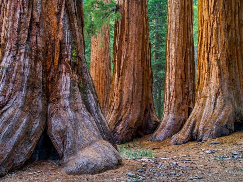
Located just inside the entrance is Yosemite’s largest Sequoia Grove, which is home to over 500 mature giant trees.
Make sure to stop by and see the Grizzly Giant, which is the largest giant Sequoia in the park.
There is a shuttle that runs to the grove during the summer from the Mariposa Grove Welcome Center at the South entrance. Or you can hike the 3.7 miles along the Washburn Trail.
📢LOCAL TIP: If you want to see larger groves of sequoias, you can drive to Sequoia National Park from Yosemite and extend your trip.
- TUOLUMNE GROVE
- 🚗Drive time and Distance: 31 mins, 16.6 miles
This popular park destination offers an opportunity to get up close to Yosemite’s Sequoias, but to see these giants, you will have to earn it,
To get to the grove from the parking lot, visitors have to negotiate a 2.7-mile trail that ascends 623 feet, which means there is a steep walk back.
We love the extra workout, but this attraction’s lack of accessibility means that it never gets overly busy.
This is a good option for those that want to see the Giant Sequoias but do not want to drive an hour and a half to Mariposa Grove from Yosemite Valley.
- HETCH HETCHY
- 🚗Drive time and Distance: 1 hour – 1.5 hours, 40.7 miles
If you are looking for a way to escape the crowds in the Yosemite Valley, then head to Hetch Hetchy for some peace and quiet by the water.
For those staying in accommodations by the Big Oak Entrance, the drive to Hetch Hetchy is much shorter and makes it worth a hike along the shores.
This area is overlooked by the vast majority of visitors, but they are missing out, especially when the Tueeulala Falls is flowing.
FAQs
Where is the Yosemite National Park entrance sign?
The Yosemite Park sign is located just a quarter mile before the Big Oak Flat Park entrance.
Anyone traveling to the park along Big Oak Flat Rd (Highway 120) will see the sign off to the side of the road nestled up against the pine trees.
Start watching closely for the sign after passing Evergreen Rd, which is the turn to get to Hetch Hetchy.
Is Yosemite near Grand Canyon?
No, Yosemite is very far away from the Grand Canyon, which is located two states away.
The drive between these two destinations is 709 miles and will take around 12.5 hours if you make very few stops.
For those hoping to see these two destinations, consider flying, or breaking up the trip with a stop in Southern California.
Is Yosemite in California?
Yes, Yosemite is located in California, in the Sierra Nevada Mountain range.
Yosemite National Park is situated halfway between the Oregon border to the north and the Mexico border to the south.
The park is located due west of San Francisco and southwest of Sacramento.
What three states is Yosemite in?
Yosemite is only located in one state, which is California.
The nearest state to Yosemite is Nevada which is only 40 miles away from the park’s eastern entrance on the Tioga Pass.
Yosemite in California is often mistaken for Yellowstone National Park, which is situated in three states, including Wyoming, Idaho, and Montana.
Where is Yosemite National Forest?
Yosemite National Park is located in Central California in the Sierra Nevada Mountain range 170 miles due west of San Francisco.
Yosemite National Forest is the wrong name for the park, as the official name is Yosemite National Park.
There are many forested areas in the park, including the Giant Sequoia groves, but the park is also home to the Tuolumne Meadows and Yosemite Valley, which offer up lots of diverse types of habitats.
Bottom Line: Where Exactly is Yosemite National Park?
📍Skipped to the end? Here is the Yosemite National Park Address: 9035 Village Dr, Yosemite Valley, CA 95389, United States
Now that you know everything you could possibly want to know about where is Yosemite National Park, all you have to do is to book a room near Yosemite and pack your bags.
Before you know it, you will be surrounded by majestic waterfalls, while you watch rock climbers scale the park’s massive granite monoliths.
Now get on your hiking shoes and get ready for an adventure of a lifetime at Yosemite National Park.
Yosemite Valley Quick Facts
- Fees: $35 per car, valid for 7 days
- Reservations: Currently not required
- Where to Stay: Yosemite View Lodge in El Portal or Yosemite Bug in Midpines for better availability.
- Getting there: The closest airport to Yosemite is Fresno Yosemite International which is 35 miles away. For the best flight deals, use Skyscanner to browse various airlines and prices.
- How to Get Around: Having your car is the easiest way to get around, especially if you’re visiting other nearby sights. Check RentalCars.com to find the best deals on rental cars.
- Best Self-Guided Tour: This audio tour from GyPSy Guide provides engaging commentary to make your trip more fun and interesting at such an incredible price!
- Insider Tip: Make sure to get the America the Beautiful National Park Pass for only $80, which allows entry to over 400+ national park sites and is valid for an entire year. Get it from REI.
![Are there Redwoods in Yosemite? [Where to Find Them]](https://cheftravelguide.com/wp-content/uploads/2023/04/redwood-trees-1-768x432.jpg)

![23 Best Cabins in Yosemite in 2023 [Where to Stay Inside the Park]](https://cheftravelguide.com/wp-content/uploads/2023/02/best-cabins-in-yosemite-1_-768x432.jpg)
![16 Best Pet Friendly Yosemite Cabins 2023 [Convenient Locations]](https://cheftravelguide.com/wp-content/uploads/2023/02/pet-friendly-yosemite-cabins_-768x431.jpg)
![Visiting Yosemite in March [Ultimate Guide]](https://cheftravelguide.com/wp-content/uploads/2022/12/Yosemite-Park-Snow_1-768x432.jpg)
![Best Cities and Towns near Yosemite [Where to Stay Outside Yosemite]](https://cheftravelguide.com/wp-content/uploads/2022/09/Yosemite_National-Park__-768x432.jpg)