
Map of Bay Area California [+ County Map, City Map, Regions]
If you are looking for a Map of the Bay Area in California, you have come to the right place.
We’ve got you covered with multiple maps covering everything from the Bay Area’s counties to the larger geographical regions.
Sprinkled in are lots of interesting facts and details you won’t want to miss that provide context to the maps.
Bay Area California Map
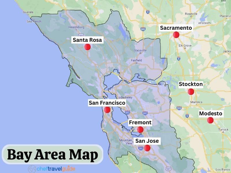
Where is the Bay Area?
The Bay Area is located in California and stretches east from the coast to the edge of the San Joaquin Valley.
The Bay Area is approximately 428 miles by air from the Oregon border and 476 miles from the Mexico border to the south.
What is considered the Bay Area in California?
The Bay area is comprised of five regions that are made up of nine counties that wrap around the San Francisco and San Pablo bays.
The entirety of the nine counties, from the most northernmost city of Cloverdale to the town of Gilroy in the south, are considered parts of the Bay Area.
Many of these farther out areas are technically the Bay Area but are far enough removed to be called into question by some residents.
Bay Area County Map
What are the nine surrounding Bay Area counties?
There are nine individual counties within the five regions of the Bay Area. Each of these counties has its own unique topography, history, and attractions that make them important pieces of the Bay Area.
San Francisco County

San Francisco county and city cover the same footprint and share the same jurisdiction.
The city by the bay is the third most visited destination by tourists on the West Coast, behind Los Angeles and Las Vegas, and drew in just over 26 million visitors in 2019.
San Francisco County offers an incredible array of attractions ranging from Gold Rush-era relics to destination neighborhoods like North Beach with their own individual style and flair.
Marin County
This affluent area which is located just across the Golden Gate Bridge from San Francisco, is the outdoor recreation center of the Bay Area.
In this region, you will find countless beaches to explore and thousands of miles of trails to hike around Mount Tamalpais and the Point Reyes National Seashore.
Muir Woods is one of the biggest tourist draws to this county, where visitors can get up close to the giant Coastal Redwoods.
Sonoma County
This large county is not only home to one of the top wine regions in California but also features some of the most breathtaking stretches of the California Coast.
The county stretches 66 miles from San Pablo Bay’s shores to Cloverdale, the northernmost and westernmost city in the Bay Area.
Top attractions to the county include the visits to the historic Sonoma Plaza for dining, and Bodega Bay, which was the set of the Alfred Hitchcock film “The Birds.”
Napa County

Napa County is home to one of the top-quality wine-producing regions in the world.
This famous wine area is a top destination for vinophiles from around the globe seeking to try out top vintages from the best producers in the region.
This elite group of wineries includes Chateau Montelena, which won the Judgement of Paris and beat the best French producers at their own game.
Napa County is also well known for its hot springs in Calistoga and world-class dining at restaurants like the French Laundry.
Solano County

Solano County is mainly comprised of commuter cities for families working in or around the Bay Area.
The primary draw to this area is for military personnel at Travis Airforce base and for business owners and employees that provide logistics and services to the base.
Although this county is mostly comprised of residential neighborhoods, large environmental areas provide refuge for wild animals, including migratory birds.
Contra Costa County

Contra Costa County is a combination of cities and towns that border Highway 80 and affluent communities nestled back in the rolling hills away from the bay.
This county offers up lots of parks and recreational areas with trails leading to spectacular viewpoints of the Bay Area.
Some of the top outdoor destinations include Tilden Regional Park, Mount Diablo State Park, and Briones Regional Park.
Alameda County
Alameda county is home to the city of Oakland, which is legendary for being a cultural and art hub in the Bay Area.
This area is well known for its music community which includes world class jazz musicians to renegade punk rock bands.
Alameda County is also home to UC Berkeley, which is a bastion of progressive politics and was made famous for protests during the Vietnam War.
Top destinations in the county include shopping on the eccentric Telegraph Ave. in Berkeley and dining at Jack London Square in Oakland.
Santa Clara County

Santa Clara County is home to the Silicon Valley and is considered the tech capital of the United States and the world.
The vast majority of the tech industry giants got their start in Santa Clara County and now are the top employers in the region.
This county includes San Jose, which is the most populated city in the Bay Area.
The city and its neighbors have the highest median monthly housing costs and per capita GDP in the United States.
San Mateo County
San Mateo county is one part suburbs that provide housing for workers around the Bay Area and charming beach towns where they go on their days off to recharge.
The top place to visit in San Mateo is Halfmoon Bay for its gorgeous sandy beaches and sandstone bluffs, where visitors can watch the sunset.
Other top attractions are Purisma Creek, for hiking in the redwoods, and Pacifica, with its combination of beginner and advanced surf breaks.
San Mateo County is also home to the world famous Gilroy Garlic Festival, where visitors can listen to live music while snacking on countless treats made with the delicious allium.
Map of Bay Area Cities
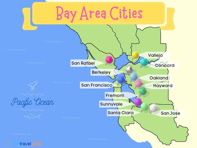
What major cities are in the Bay Area?
The Bay Area has three major cities: San Jose, San Francisco, and Oakland.
San Jose is the largest, with over one million residents in 2020. San Francisco is second with 873,000, and Oakland is the third largest with 440,000 residents.
While San Jose is the largest, San Francisco is the top tourist draw to the Bay Area, with just over 26 million visitors in 2019.
What cities cover the Bay Area?
There are 101 Bay area cities ranging from major cities like San Jose, with over one million residents, to small towns like Colma, with a population of just 1500 people.
Some are big tourist destinations, while the vast majority are suburban commuter cities that provide housing and necessary services to the Bay Area’s 7.7 million residents.
Bay Area Cities by County
This list includes the major cities in the bay area divided by county.
San Francisco County
- San Francisco
Santa Clara County
- San Jose
- Sunnyvale
- Santa Clara
Alameda County
- Oakland
- Fremont
- Hayward
- Berkeley
- San Leandro
- Livermore
Sonoma County
- Santa Rosa
Solano County
- Vallejo
- Fairfield
- Vacaville
Contra Costa County
- Concord
- San Ramon
- Richmond
- Antioch
San Mateo County
- San Mateo
- Daly City
Different regions of the Bay Area

The Bay Area is comprised of five regions of different sizes that surround the San Francisco Bay.
These regions contain the nine counties that make up the Bay Area but are broken down into geographical areas.
San Francisco
San Francisco is its own city, county, and region in one.
It is the smallest of the Bay Area regions, with a footprint of only 47 square miles.
This region is the tourist center of the Bay Area, with 26 million tourists visiting in 2019.
- Largest City: San Francisco
- Included Counties: San Francisco
North Bay

The North Bay region is the largest in the Bay Area, with over 3666 square miles of vineyards, farmland, and state and national parks.
The region is well known for being the wine capital of California, with the world-famous Napa and Sonoma Valley’s located within its boundaries.
This area is also a hot spot for nature enthusiasts that flock to walk amongst the Coastal Redwoods or hike the trails in the Point Reyes National Seashore.
- Largest City: Santa Rosa
- Included Counties: Marin, Sonoma, Napa, Solano
East Bay
The East Bay offers a range of upscale commuter cities in the suburbs and densely compacted urban areas that are the cultural centers of the Bay Area.
This region is best known for being the home of UC Berkeley, which is one of the top colleges in the nation and famous for its liberal politics and protests.
The area is also home to great parks and nature areas, including the massive Tilden Regional Park and Mount Diablo State Park.
- Largest City: Oakland
- Included Counties: Contra Costa, Alameda
South Bay

This region is often referred to as the Silicon Valley and is considered the world’s tech capital.
The region was first known for Stanford University, one of the nation’s top private institutions.
Later, the tech boom started in Palo Alto, and now the South Bay has the highest GDP per capita in the United States.
San Jose and the surrounding cities are home to tech giants, including Apple, Google, Meta (Facebook), Intel, and many more.
- Largest City: San Jose
- Included Counties: Santa Clara
Peninsula
This region and county in one is made up of a combination of sprawling suburban cities and quaint beach towns along the coast.
The main cities are Daly City and San Mateo, with a relatively low population of under 102,000 people.
The main attraction to the area is Highway 1 or Pacific Coast Highway, where visitors cruise the California Coast, stopping at the many beaches in Halfmoon Bay or for surfing in Pacifica.
- Largest City: San Mateo
- Included Counties: San Mateo
What is not part of the Bay Area?
Counties and regions that do not at least touch the San Francisco or San Pablo bays are not included in the Bay Area.
All nine counties in the Bay Area have at least a small area that touches the bays.
This means that areas including Santa Cruz and Sacramento counties are not included, even though they are close to or touching the Bay Area.
Is Discovery Bay in Bay Area?
Yes, Discovery Bay and its neighboring golf course are in the Bay Area in eastern Contra Costa County.
While this planned community is technically in the Bay Area, it is closer to Stockton in the San Joaquin Valley than it is to the San Francisco Bay.
Anyone visiting Discovery Bay will have a tough time recognizing it as the Bay Area, even though it is located in one of the nine Bay Area counties.
Which city is close to the Bay area?
The closest large city to the Bay Area is Sacramento which is less than 15 miles from the edge of Solano County.
The other cities that are close to the Bay Area include Stockton and Modesto, which are within 40 miles of Contra Costa and Alameda counties within the Bay Area.
About Bay Area, California
Best Time to Visit
The best time to visit the Bay for weather is the early fall. The fog will subside for the season, and the sun is out on most days, offering just enough warmth without being hot.
This time of year is just after the busy tourist season as kids are back in school and people are preparing for their holiday breaks.
This means you will get great weather in September and October, but you won’t have to share the city’s attractions with many other tourists.
The other benefit is that prices of highly-rated hotels will be lower, and reservations at the Bay Area’s top restaurants will be easier to come by.
Bay Area Weather

The Bay Area weather is considered Mediterranean, but the region has unique characteristics that make for special conditions.
While San Francisco and the whole Bay Area face all four seasons each year, the overall temperature swings are held in check by the Pacific Ocean.
Another contributing factor is the wind that comes off the ocean and can make even a sunny summer day chilly.
Summer
- Average coastal temperatures: High 72° Low 56° F
- Average inland temperatures: High 83° Low 57° F
Summertime highs can jump up to over 100° F in the more inland areas, but cities surrounding the bay typically get socked in with fog.
This summer fog in the bay offers a reprieve from the heat that hits the rest of the state.
Fall
- Average coastal temperatures: High 69° Low 55° F
- Average inland temperatures: High 74° Low 54° F
Typically the Fall remains fairly dry, with less than two days of rain on average between September to October.
During the Fall, the fog subsides, offering plenty of sunshine.
Winter
- Average coastal temperatures: High 59° Low 47° F
- Average inland temperatures: High 57° Low 45° F
Winter brings cooler temperatures with lows in the mid to high forties and daytime highs in the Mid-fifties. This is relatively warm, but some inland areas can be much colder.
This is also when the bay area gets most of its rain, with an average of eight days per month.
Spring
- Average coastal temperatures: High 65° Low 51° F
- Average inland temperatures: High 69° Low 49° F
Spring in the Bay area starts with a decent amount of rain, but it quickly tapers off, resulting in some gorgeous weather with highs in the mid-sixties to low-seventies.
Be warned that by May, the fog starts to creep in, blocking the sun, making it very chilly, and obstructing views of attractions like the Golden Gate Bridge.
Why is the Bay Area so famous?
The Bay Area is famous worldwide because of the world-class tourist destination of San Francisco and the Silicon Valley, which is the epicenter of global tech.
This California region is also famous for being the center of the Summer of Love during the sixties when hippies flocked to the area.
The Bay Area has also been featured and used in filming countless movies and television shows, including the Matrix 4 and the sitcom Full House.
Top Things to do in the Bay Area


The Bay Area offers enough fun places and attractions to keep visitors busy for months, if not years.
We narrowed it down to what is the must-see and experience attractions in the Bay Area.
- Walk the Golden Gate Bridge and take photos of its expanse from Battery Spencer, which overlooks San Francisco.
- Visit Muir Woods National Monument and walk amongst the giant Coastal Redwoods.
- Hike with the wild elk at Tomales Point in the Point Reyes National Seashore.
- Take a relaxing break at the Japanese Tea Garden and the San Francisco Botanical Garden.
- Wiggle your toes in the sand and catch some rays at one of the 13 beaches in Half Moon Bay.
- Enjoy views of the Bay Area from the top of Twin Peaks or Mount Diablo in the East Bay.
- Eat locally caught Dungeness crab and freshly baked sourdough at Fishermans Wharf.
- Take a tour of the campuses of Google and Facebook (Meta) to get a firsthand look at these tech giants.
- Visit UC Berkeley and Stanford University to walk the hallowed grounds of two of the top colleges in the United States.
- Take a cruise to Alcatraz for a self-guided audio tour or for sunset views from under the Golden Gate Bridge.
FAQs: Map of SF Bay Area
What is the nicest part of the Bay area?
The nicest part of the Bay Area is in Atherton and Portola Valley in San Mateo County.
These affluent communities have the highest median home sale prices in the region for 2022 at 5.9 million for Portola Valley and 10.1 million for Atherton.
Marin is also one of the most affluent areas of the Bay Area, and it is also home to the Point Reyes Nation Seashore, Mount Tamalpais, and the Golden Gate National Recreation Area.
Other nice parts of the Bay Area include the Napa and Sonoma valleys, the Sea Cliff neighborhood in San Francisco, South Bay towns like Palo Alto, and bayside communities like Belvedere.
What is special about Bay area in California?
The Bay Area in California offers a combination of world-class tourist attractions like the Golden Gate Bridge, along with nature areas like Muir woods and wine-growing regions that are the envy of the world.
There are amazing things to do and experience, but the weather is also mild, making it perfect for exploring all year.
Where is the richest place in the Bay Area?
The richest place in the Bay Area is the South Bay communities that surround San Jose.
This portion of the Bay Area has the highest per capita GDP and median income in the United States.
This high GDP comes along with the highest average median household income in the United States of over $110,000 per year.
Is Bay Area California expensive?
Yes, the Bay Area is one of the country’s most expensive places to live, with housing costs near the top of the list.
Not all of the Bay Area is expensive, as many cities along key corridors away from the major cities offer rental prices or homes for sale at prices slightly higher than average in California.
The overall cost of living is higher than in most of the United States, but it is in line with the higher average income in most areas.
Does the Bay area have a beach?

Yes, the Bay Area features amazing beaches ranging from the more rugged options to the north along the Sonoma Coast to the sandy bluff side beaches in Half Moon Bay.
There are countless options along the coast, including large stretches in San Francisco like the 3.5 mile long Ocean Beach.
This Region offers beaches for every taste, including small coves and clothing-optional spots for the less inhibited.
Is the Bay Area a region?
Yes, the Bay Area is a populous formal region that is clearly defined by the boundaries of its nine counties.
Within the Bay Area are five functional regions based on geographical proximity to the San Francisco Bay.
Is the Bay Area in Northern California?
Yes, San Francisco is located in Northern California, one of the state’s three major regions.
California is so large that it is broken up into three regions, including Southern, Central, and Northern California.
Government agencies do not clearly define these areas, opening the door to opinions and preconceived notions about the boundaries.
Wrap-Up: Map of the Bay Area in California
Now that you have had a chance to peruse the map of the Bay Area in California and learn a lot about the region, you can check out our other articles and plan your trip to the Golden State.
![Is San Jose in the Bay Area? [Everything You Need to Know]](https://cheftravelguide.com/wp-content/uploads/2023/01/bay-area_-768x432.jpg)
![19 Best Redwoods near San Francisco [Ultimate Guide]](https://cheftravelguide.com/wp-content/uploads/2022/10/Redwoods-Near-San-francisco__-768x432.jpg)
![10 Warm Beaches near San Francisco [Great for Swimming!]](https://cheftravelguide.com/wp-content/uploads/2023/08/drakes-bay-768x576.jpg)

![How to Get from Oakland Airport to San Francisco [4 Easy Ways]](https://cheftravelguide.com/wp-content/uploads/2022/06/oakland-airport-to-san-francisco__-768x432.jpg)
![San Francisco to Sacramento: 7 BEST WAYS [2023]](https://cheftravelguide.com/wp-content/uploads/2022/07/Sacramento-CA_-768x432.jpg)